Latest Courses
ISTQB Artificial Intelligence Tester Sample ExamsCheck course
JAVA Programming Online Practice ExamCheck course
Programming for Kids and Beginners: Learn to Code in PythonCheck course
Practice Exams | Codeigniter 4 developer certificationCheck course
WordPress Practice Tests & Interview Questions (Basic/Adv)Check course
Git &Github Practice Tests & Interview Questions (Basic/Adv)Check course
Machine Learning and Deep Learning for Interviews & ResearchCheck course
Laravel | Build Pizza E-commerce WebsiteCheck course
101 - F5 CERTIFICATION EXAMCheck course
Master Python by Practicing 100 QuestionCheck course
ISTQB Artificial Intelligence Tester Sample ExamsCheck course
JAVA Programming Online Practice ExamCheck course
Programming for Kids and Beginners: Learn to Code in PythonCheck course
Practice Exams | Codeigniter 4 developer certificationCheck course
WordPress Practice Tests & Interview Questions (Basic/Adv)Check course
- 75% Server-side web GIS applications with Leaflet and PostGIS

Server-side web GIS applications with Leaflet and PostGIS

$25.00Track price

Add your review
Add to wishlistAdded to wishlistRemoved from wishlist 1
Add to compare
8.3/10 (Our Score)
Product is rated as #222 in category Web Development

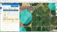
Server–side web GIS applications allow you to access GIS data stored in a multi–user database. This means that your data will always be current and any changes that other users make to the data will be immediately available in your application. You will be able to build complex GIS applications where some users will only be able to view certain data that you allow them and other users will be able to add, edit, and delete data from a web–interface. This means that your users will be able to interact with your GIS database from any device that has a compatible browser and an internet connection. They may be working in the field from a mobile device or from home on a mac OS computer, or on the other side of the world on a Linux computer.

This course uses PHP for the server–side language because of its popularity and its wide availability on web servers. We will use PostGIS as a spatial database, again because of its popularity and common usage in GIS applications. I teach standard web development methods that have stood the test of time and will still be available in many years after the latest, greatest, technology has been replaced with something even better. My goal as an instructor is to provide an introduction to the basic concepts. I don’t think you will find any limitations with the software that I teach but if you ultimately decide to use a different server–side language, database, or a newer framework the methods you learn here will provide a solid foundation.

Instructor Details

I have been programming and working with database applications for over 30 years, and specializing in geospatial applications for over 20 years. I am a believer in the 80/20 pareto principle which suggests that you only need to understand 20% of a subject in order to do 80% of your work. My goal in all my courses is to teach at the level of that 20% sweet spot and to provide my students with the background and the tools they need to learn the rest of what they need on their own.

Specification: Server-side web GIS applications with Leaflet and PostGIS

Duration

16.5 hours

Year

2019

Level

Intermediate

Certificate

Yes

Quizzes

No

6 reviews for Server-side web GIS applications with Leaflet and PostGIS

4.1 out of 5
4
0
1
0
1
Write a review
Show all Most Helpful Highest Rating Lowest Rating
  1. Semih MEMIS

    Detailed

    Helpful(0) Unhelpful(0)You have already voted this
  2. Paulo Henrique Vianna

    Muito bom.

    Helpful(0) Unhelpful(0)You have already voted this
  3. Jovanni Jabat

    Great course for GIS.

    Helpful(0) Unhelpful(0)You have already voted this
  4. Adrian Diaconu

    very good. worth the money!!!

    Helpful(0) Unhelpful(0)You have already voted this
  5. Mike Baker

    I have taken several courses by this instructor. He always does a great job presenting the material.

    Helpful(0) Unhelpful(0)You have already voted this
  6. Arthur Gailes

    The course is fine, but he doesn’t answer any of the user questions or offer any support.

    Helpful(0) Unhelpful(0)You have already voted this

    Add a review

    Your email address will not be published. Required fields are marked *

    This site uses Akismet to reduce spam. Learn how your comment data is processed.

    Server-side web GIS applications with Leaflet and PostGIS
    Server-side web GIS applications with Leaflet and PostGIS

    $25.00

    Price tracking

    Java Code Geeks
    Logo
    Register New Account
    Compare items
    • Total (0)
    Compare