
GIS and Drone Technologies are both powerful tools for assisting people in analyzing the world we inhabit. Whether you are someone with GIS skills looking to add drones to your toolbelt, or a drone pilot who wants to level up their deliverable products, you are in the right place. Both these skills require very similar mindsets, such as an attention to detail, focus and accuracy. If you can do one, you can do the other, so why not do both!
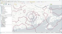
This course is best for those who have some familiarity with either GIS concepts or drone mapping, or those that are comfortable in learning new software packages. The course is perfect for those who have drone data that they have collected and want to analyze it beyond running it through Drone Deploy and the like. Using your DEM data, you will learn to create elevation contours, calculate the terrain’s steepness and which way the sun is hitting the ground. You will also learn the skills to go online and acquire existing data layers such as town boundaries, watershed areas, and streams and overlay them atop your orthomosaics. From there, you add professional borders, titles, scale bars and your logo and produce professional client deliverables, thereby surpassing your competition.
Specification: GIS for Drone Pilots using QGIS (w/ Airspace Data Template)
|
User Reviews
Be the first to review “GIS for Drone Pilots using QGIS (w/ Airspace Data Template)”
| Price | $14.99 |
|---|---|
| Provider | |
| Duration | 3.5 hours |
| Year | 2022 |
| Level | All |
| Language | English ... |
| Certificate | Yes |
| Quizzes | No |

$14.99


There are no reviews yet.